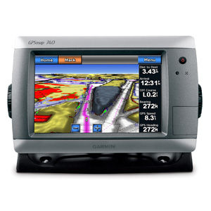
GPSMAP 740
A stand-alone touchscreen chartplotter that brings a new level of functionality to your vessel
GPSMAP 740 is a stand-alone touchscreen chartplotter that brings a new level of functionality to your vessel. Featuring a brilliant 7-inch (17.78 cm) display, GPSMAP 740 puts all the information you need right at your fingertips. GPSMAP 740 is preloaded with U.S. coastal maps. In addition, GPSMAP 740 accepts radar input and offers full NMEA 2000® connectivity for greater convenience when adding extra sensors.
Explore the Seas
GPSMAP 740 contains preloaded map data for all U.S. coastal areas, including Alaska and Hawaii, plus Explorer Charts for the Bahamas. GPSMAP 740 also features an internal, high-sensitivity GPS receiver for superior satellite tracking and quicker acquisition times. And as an added benefit, GPSMAP 740 can receive graphical weather data for North America through the optional GXM™ 51 satellite receiver/antenna (sold separately).
Take Control by Touch
Input is easy with GPSMAP 740. Whether you’re changing course or simply reviewing information in front of you, the intuitive touchscreen interface makes for simple operation. The device also offers flexible brightness levels for daytime readability along with low-light dimming during night use. And with a widescreen display that’s rugged and water resistant, it’s made to perform in any situation.
Expand with Radar
Featuring a built-in radar port, GPSMAP 740 can be interfaced with Garmin’s line of affordable GMR™ marine radar systems (sold separately). Whether you’re adding radar now or in the future, you’ll enjoy the convenience of “plug-and-play installation” as well as the power, range and high-definition targeting of our proven radar offerings.